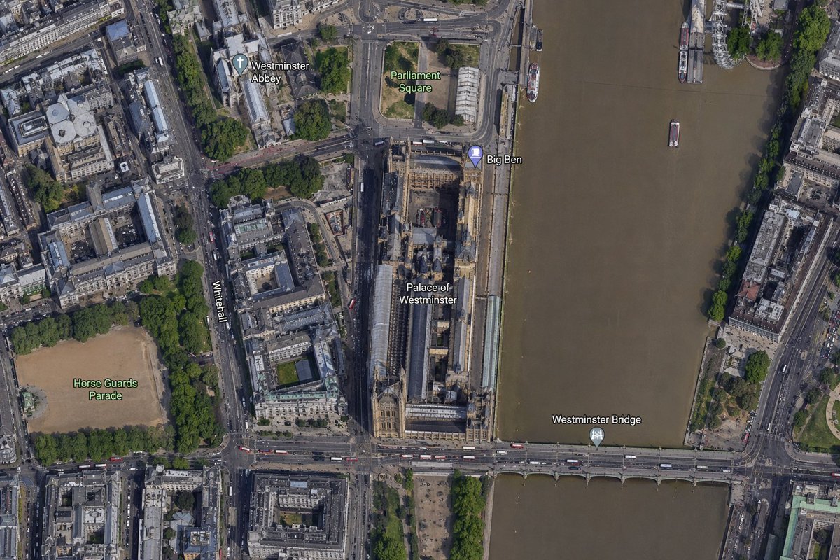
Satellietkaart van het gebied rond Big Ben
Deze prompt genereert een realistische, van labels voorziene luchtfoto in satellietstijl, gecentreerd op de Big Ben en het Palace of Westminster. Deze kaart is handig voor kaartvergelijkingen, locatievisualisaties en afbeeldingen die de geografische context illustreren.
Dit is een voorbeeld van een GPT Image 2 prompt voor Landschap & Natuur . Gebruik de onderstaande kant-en-klare prompt om vergelijkbare afbeeldingen te genereren en controleer de Awesome GPT Image 2 Prompts en de rechten voor commercieel gebruik voordat u de afbeeldingen hergebruikt.
Free 1K preview
Generate one preview image instantly, no sign-up required.
Snel
Schrijfklare prompt
A high-resolution top-down satellite map view of central {argument name="city" default="London"}, focused tightly on the area around {argument name="landmark" default="Big Ben"} and the Palace of Westminster beside the River Thames. Show a realistic aerial orthographic perspective like a modern digital map or satellite layer, with detailed rooftops, streets, trees, shadows, and brownish river water. Place the long Palace of Westminster complex vertically near the center-right, directly along the west bank of the river, with Big Ben at the northeast corner of the palace near the river edge. A bridge labeled {argument name="bridge name" default="Westminster Bridge"} crosses horizontally near the bottom of the frame from left to right over the river. Include 6 visible map labels total: {argument name="label 1" default="Westminster Abbey"}, {argument name="label 2" default="Parliament Square"}, Big Ben, Palace of Westminster, Westminster Bridge, and Horse Guards Parade. Also show Whitehall as a labeled road running vertically on the left side of the palace area. Surrounding details should include Westminster Abbey in the upper left quadrant, Parliament Square above the palace, Horse Guards Parade as a large sandy rectangular ground in the lower left quadrant, dense city blocks and roads on the left half, the River Thames occupying the full right side, embankments on both sides, a few boats on the river, and tree-lined streets and parks. Use natural satellite-image colors, crisp cartographic label overlays, and the look of a zoomed-in online maps screenshot.Vraagvariabelen
Bewerkbare argumentplaceholders in de prompt, met hun standaardwaarden.
Best for
- - Landschap & Natuur visual exploration
- - Image generation and reference-image edits
- - Reusable briefs that keep source attribution visible
Change these parts
- - Subject, product, character, or scene
- - Aspect ratio, camera, lighting, and background
- - Brand, text, color, and output constraints
Recommended model and settings
- - Model: gpt-image-2
- - Input mode: Tekst naar afbeelding
- - Aspect ratio: source
- - Commercial status: review original source
How to use this prompt
- 1. Copy the prompt and preserve its structure for the first test.
- 2. Replace the subject, context, and publishing channel.
- 3. Change one camera, lighting, or style variable per iteration.
- 4. Inspect the output, source, text, and rights before reuse.
Limitations, source, and reuse cautions
- - Generated output is an editable draft, not factual, legal, or rights evidence.
- - Review the linked source, people, brands, logos, text, and third-party media before commercial use.
Meer gevallen in deze categorie
Geprioriteerd op basis van categorie, compatibiliteit met invoermodus, kwaliteit en lager risico.
Hergebruik en bronvermeldingen
Gebruik deze prompt veilig nadat u de casus hebt bekeken.
- 1.Kopieer de prompt of open deze direct in Dovoo met de knop 'Genereren'.
- 2.Pas de variabelen, beeldverhouding en referentieafbeeldingen aan uw eigen toepassing aan.
- 3.Controleer vóór publicatie of betaald gebruik de auteursrechten, de vereisten voor naamsvermelding en de risico's met betrekking tot merk of beeltenis.